Waitsfield has hired consultants to help its planning commission modernize the town’s land use regulations to foster more infill development in hopes of helping address the need for more housing in Waitsfield and The Valley.
Planning commissioners heard from consultants Julia Randall and Alex Belensz with the Burlington-based SE Group on January 17 when they presented an analysis of current zoning and where and/or how it can be changed with a goal of increasing density in Waitsfield’s growth centers while creating a more walkable and pedestrian-friendly village.
The consultants told commissioners that they were focusing on the Waitsfield Village Residential District, the Waitsfield Village Commercial District and Irasville. They noted that the Town Plan calls for concentrating development to preserve the historic and rural character of the town while promoting sustainability. The plan also calls for ensuring adequate infrastructure to support concentrated development.
HOUSING STUDY
They pointed to a recent housing study that identified a need for at least 61 housing units in the town, with 40 of those units needed for lower income people and 21 for moderate income folks.
Working through each district, the consultants looked at current settlement patterns, land use and density analysis, bylaws, Town Plan recommendations and opportunities and constraints.
In the Village Business District, the consultants found the average lot size was 0.44 acres, the median lot size was 0.32 acres. Average building coverage on developed lots was 19.1% and the median building lot coverage was 18.2%. In this district, commercial uses made up 88%, residential uses made up 8%, and miscellaneous uses 4%. Based on lot size and coverage this district is approximately 2.5 times more densely developed than Irasville.
CONDITIONAL USE APPROVAL
Focusing on specifics of the bylaws for the Village Business District the consultants noted that all uses are subject to conditional use approval other than those that are use by right such as single-family dwellings. They suggested changing this standard noting that multifamily housing is not listed as a permitted use. They said that increasing building height would allow for more mixed-use buildings with residential units on higher floors.
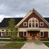
The main area of their focus, however, is Irasville. They told commissioners that this area resembles a piecemeal 20th-century commercial strip development as opposed to a traditional village center grid. They noted that the area feels jumbled and disconnected and that it is lacking in pedestrian connections. This area is relatively low density for a village area; there are large surface parking areas and primarily two-story buildings. Some commercial uses have small setbacks creating a more pedestrian-friendly feel while others are set back further and more disconnected from the pedestrian network.
LACK OF CIVIC SPACES
Irasville is notable for its lack of formal civic spaces and its residential uses are primarily multi-family, they said. Average lot size in Irasville is 2.32 acres with median lot size at 1.11 acres. Average building lot coverage is 6.4% and median building lot coverage is 7.7%. In this district commercial uses make up 41% of the area, residential uses make up 43%. Industrial uses make up 1% of the area and miscellaneous uses make up 16% of the area.
As with the Village Commercial District, in this district all uses are subject to conditional use approval except for those allowed as uses by right including forestry, agriculture, single-family homes and accessory dwelling units. Multifamily housing is not listed as a permitted use in this district. Town Plan goals for Irasville include upper story dwelling units, higher density residential development, increasing maximum height limits, reducing setbacks, and creating a more pedestrian friendly environment. Further goals include consolidating parking to free up plans for other uses. The consultants pointed out that Irasville is constrained by the wetlands, and the river corridor as well as the cemetery. They noted that there is a lack of an authoritative master plan and that the current layout is car-centric.
They told the commissioners that Irasville is lacking a character, and that it might make sense to create a core area or hub in this district and focus intensely on development there.
TRADITIONAL NEW ENGLAND CENTER
The Waitsfield Village Residential District, they found, has a traditional New England center and layout. They did note that are adjacent large rural areas surrounding this district. The district provides primarily multifamily residential with some single-family and commercial retail spaces. The area is walkable and well served by its sidewalks and has a notable historic architectural character with one-, two- and three-story buildings.
In this district, average lot size is 1.81 acres, median lot size is 0.17 acres. Average building lot coverage for developed lot is 4.8%, median building lot coverage for development is 10.3%.
Residential uses are 55% of the Village Residential District, commercial uses are 19%, miscellaneous uses are 26%. According to the consultants this district is half as densely developed as the Village Business District. The current zoning for this district only allows multifamily dwellings of up to two units and the consultants that the district boundaries seem arbitrary because they split some properties, wetlands, and forest blocks.
In this district, the consultant suggested the town might look at refining district boundaries, increasing building height maximums, particularly for accessory dwelling units, consider small-scale planned unit developments, and offer more granular recommendations about housing types for example cottage courts. Additionally, they suggested broadening the definition of multifamily to include more than two units and allowing building footprint is greater than 4000 ft.
Outside of these three designated group centers, the consultants suggested the best way to increase density in other districts is through planned residential development, and planned unit developments
HOW MUCH GROWTH
The consultants asked the planning commissioners how much growth should these three districts absorb, and where should most developments occur. Several planning commissioners expressed skepticism that those three designated group districts could absorb enough housing to make a meaningful contribution. One planning commissioner asked if it might be feasible to change the zoning for ag/res parcels that abut designated growth areas so that they could have increased density.
The consultants responded that that might be an interesting idea, to provide special standards for suitable parcels that abut growth centers but cautioned that Smart Growth principles call for a more compact development pattern with access to municipal water and wastewater.
The planning commission will continue its work with consultants and it will be holding public hearings to take feedback from community members.