On June 11 and 12, teams of Mad River Watch volunteers visited field sites to collect data and make environmental observations for the first time this summer. This article is part of an ongoing series that shares highlights from this field work, lessons learned from this year and the past 39 years of Friends of the Mad River’s (FMR) Mad River Watch program. This summer’s articles focus on exploring the Mad River in the context of its surrounding watershed.

WHAT IS A WATERSHED?
At first glance the Mad River seems to begin in the headwaters in Warren and end in its confluence with the Winooski in Moretown. But a closer look makes it clear that the while the Mad River really does end its journey by emptying into the Winooski, its beginnings are found all over The Valley. From seeps of groundwater on mountain slopes, late winter snow, or a rainy afternoon, water gathers and the smallest of streams are formed. These miniature tributaries join together before taking on familiar names, like Mill and Shepard Brook. Along the way, these natural branches are joined by water gathered into human-dug ditches, filled with runoff from roads, rooftops, lawns, and farmland. All the while, water works its way deeper underground, refilling aquifers and slowly releasing through springs, wetlands, and into the Mad River. All this water coming from all over the landscape is called a watershed. It is the area of land that drains into a body of water – in this case, the Mad River.
WATCHING THE WATERSHED
Over the last 30-plus years of Mad River Watch, volunteers have helped FMR learn about the river and how this community relates to it. FMR learned that E. coli levels are highest after it rains, likely the result of stormwater picking up the bacteria from the land. Recognizing this pattern makes it clear that swimmers should wait 24 hours after rain before going for a dip. As the program has grown, volunteers have shifted their focus to understand the evolving connection between the health of the river and the health of the broader watershed. Monitoring the health of riparian buffers (the forested area alongside the river) and water temperature at the same time allows FMR to highlight the beneficial impacts of these buffers – they help keep the water cool enough for species like native brook trout to thrive.
OBSERVATIONS FROM THE FIELD
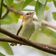
Seasonally expected temperatures marked both field days, with recorded air temperatures across the watershed ranging from a low of 59 degrees F on Monday morning along the Folsom Brook to 73 degrees F along North Road in Moretown later that same morning. Water temperatures remained comfortably cool across much of the watershed. A low of 52 degrees F was recorded in Lincoln Brook on Sunday and a high of 66 degrees F was recorded in the mainstem of the Mad River near North Road on Monday. Some of the warming seen at the North Road site was likely due to the recording being taken later in the day. Average pH across all sites was 6.8, with all measurements in a range between 6.5 and 7.5. Water levels were a mixture of low and moderate flows across the watershed. Volunteers noted many bird species at their sites including spotted sandpipers, mergansers, phoebes, vireos, chestnut-sided warblers, oven birds, and yellow warblers.
FIELD NOTES FROM WARREN COVERED BRIDGE
“60F sunny and warm after a few days of light rain and wildfire smoke from Quebec. Site Looks pretty much the same as last year. Water level remains low. Eddy on the near side continues to collect algae. Lots of birdsong and a few water birds. pH slightly acidic (<6), maybe from the wildfire smoke?” noted Julie and Ingrid Westervelt.