
The Waitsfield Development Review Board has classified a proposed eight-lot subdivision off Bushnell Road as a major subdivision and outlined a series of environmental and planning requirements the applicant must address before moving forward in the permitting process.

The determination came during a May 12 sketch plan review for a proposal submitted by Dana Hinman for property at 319 Bushnell Road in Waitsfield’s Agricultural-Residential District.
The proposal calls for subdividing an existing 36-acre parcel into nine residential lots ranging in size from about 2 acres to 7 acres. However, the applicant told the board that the property may be closer to 53 acres based on tax map information. Officials said a formal survey conducted before preliminary plan review will determine the exact acreage.
EXISTING HOME
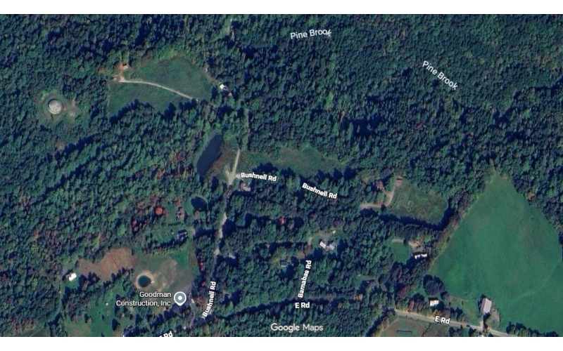
According to documents filed with the town, the property is divided by Bushnell Road into eastern and western sections. The existing home and garage are located on the eastern side of the parcel and would remain, though on a reduced lot.
The proposal includes eight new residential lots in addition to the existing homesite. Lots 1 through 4 would be accessed using an existing private driveway east of Bushnell Road, while lots 5 through 8 would access the property directly from Bushnell Road on the western side.
Each proposed lot would rely on individual drilled wells and on-site septic systems. Only conceptual building envelopes have been submitted at this stage of the review process.
In its written determination, the Development Review Board (DRB) said the project qualifies as a major subdivision under Section 2.1 of the Waitsfield Subdivision Regulations because it involves the creation of nine lots. Major subdivisions are subject to additional scrutiny and must comply with standards outlined in Article 3 of the regulations.
MAJOR SUBDIVISION
The board also noted that under town regulations, projects may be classified as major subdivisions if they pose “a significant threat of an undue adverse impact to natural or cultural resources identified in the Town Plan or through site investigation.”
According to state wetlands inventory mapping and preliminary site plans, Class II state-regulated wetlands exist on both the eastern and western portions of the property. The applicant stated in submitted materials that the proposed development would avoid impacts to those wetlands.
The board also cited mapped habitat blocks and moderate-priority Deer Wintering Areas identified through Vermont Agency of Natural Resources mapping.
WILDLIFE HABITAT
The DRB outlined several recommendations and requirements that the applicant must address before submitting a preliminary plan application. The applicant must provide a tree-cutting plan and obtain feedback from the Vermont Department of Fish & Wildlife regarding the proposed development’s impact on wildlife habitat and deer wintering areas.
The applicant also must obtain confirmation from the state Wetlands Division establishing the exact location of Class II wetlands on the property before the next phase of review can proceed.
Town officials additionally plan to evaluate whether the proposed subdivision could affect the town water tank and access to it. DRB members asked JB Weir, the Waitsfield Planning and Zoning Administrator, to obtain feedback from the town regarding any potential impacts before preliminary plan review.
SIX MONTHS
The board further required that a site visit be conducted before preliminary review and that all proposed development envelopes be staked in the field at their approximate centers.
No waivers from subdivision regulations have been requested at this stage, according to the determination.
The sketch plan review marks the earliest formal phase of the subdivision review process and is intended to identify major planning, environmental and infrastructure issues before applicants prepare detailed engineering and permitting documents.
Under Waitsfield subdivision regulations, Hinman must submit a preliminary plan application within six months of the board’s determination to continue the review process.
The proposed subdivision comes as local communities continue to grapple with balancing housing development pressures against environmental protections and rural land-use priorities, particularly in areas with sensitive wetlands, steep slopes and wildlife habitat.
The property contains steep slopes, though the applicant stated in project materials that the proposed development areas were intentionally sited to avoid significant impacts to those areas.
Because the project remains in the sketch plan phase, the exact layout, lot boundaries, road access details and development impacts could change before any final approval is considered by the board.