(Written by Ross Saxton with contributions by partners of stewardMRV. Saxton is the executive director of the Mad River Path. Trail mix is a series about trail building, trail management and recreation in and around the Mad River Valley.)
It’s safe to say that most people come to the Mad River Valley for the outdoor recreation opportunities and the natural beauty all around. Or as the chamber puts it, “Come for the mountains. Stay for The Valley.” Among the mountains and The Valley are more than 60 miles of officially managed multi-use trails. Add snowmobile trails and the Long Trail into the mix and that number exceeds 100 miles. That’s a pretty big number to tackle when one might only have a weekend to spend in the Mad River Valley. Where to start? Even for residents or those who visit every year it can be daunting to take in all that The Valley has to offer. On top of that, there are several organizations who build and maintain these trails. Who to follow for info and updates? This article, split into two parts, will help people figure out how the pathways and trails work in The Valley and shed some light on the organizations behind their stewardship.

TRAILS FOR EVERYONE
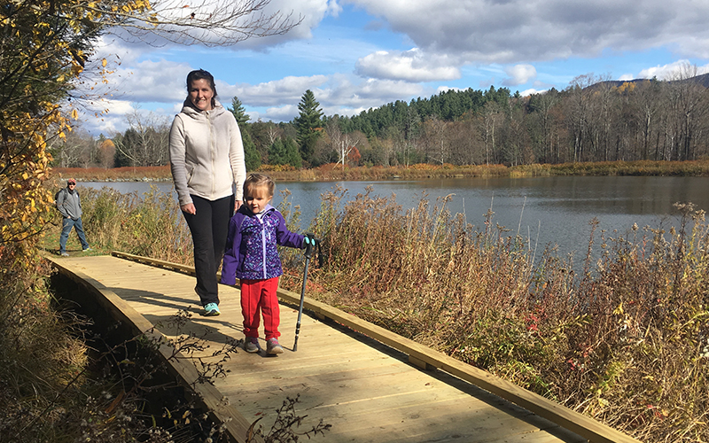
From the lowest pebble in the Mad River to the highest rock on the Monroe Skyline, there’s a trail to get there. For folks looking for a leisurely stroll or a safe place for wheelchairs and other mobility devices, the Mad River Path offers several sections. Many of these paths are near the Mad River and its swimming holes, while the section named “Heart of the Valley” winds through downtown Irasville and Waitsfield just steps away from more than 50 businesses. The boardwalk between the Skatium and Lawson’s Finest even features a relatively new beaver pond that keeps getting better for wildlife viewing. The West Greenway off Meadow Road is mostly mowed grass and provides views of both the Mad River and the Green Mountain range, including Sugarbush and Lincoln Peak. Another great trail network that’s oriented towards hiking and running is found on the Harwood Union High School property -- both easy and challenging trails are found here and are open to the public outside of school hours. It can get a bit confusing on the Harwood trails while getting to know this system, so be sure to pay attention out there.
For trails with more elevation, rocks, roots and twists than The Valley-bottom paths, the hills and mountains are where to go. Primarily built and managed by the Mad River Riders, more than 54 miles of multi-use trails wind through private and public land. All are open to the public for biking, running, walking and skiing or snowshoeing in the winter. These trails can be found across The Valley, ranging from Blueberry Lake in the south to Moretown in the north. Everyone from toddlers to expert riders will enjoy the network at Blueberry Lake. Start off with a loop on Tootsie Roll. If desiring more, head to Amenta's Way and stop to take in the view at the lookout. For a bit more challenge and a little solitude, check out Chain Link and East Loop, in the Camel’s Hump State Forest, where there’s almost three miles of hand-built single track with challenging rock features.
The conservation commissions of Warren, Waitsfield and Fayston are partners in managing trails on town land, like at Chase Brook Town Forest, Scrag Mountain Town Forest, Wu Ledges Town Forest, Boyce Hill Town Forest and Eaton Town Forest, above the Warren Skate Park. These trails are often tucked away and sometimes offer less traffic than other spots.
Co-located with other trails in places, the XC skiing-oriented Catamount Trail travels through The Valley and offers year-round recreation on most of the stretch (a short stretch south of the Route 17 crossing is skiing only). Another trail that passes through the upper reaches of The Valley is the Long Trail. It’s a rough and tough trail with a lot of views. Getting to the Long Trail is easy by vehicle on Lincoln Gap or App Gap (while shoes or boots will get people there through Sugarbush’s Lincoln Peak or Mt. Ellen access roads, up Mad River Glen, or the Hedgehog Brook Trail in Fayston. During the winter, groomed XC ski trails are at Ole’s and Blueberry Lake Cross Country Center by purchasing a ski pass in support of two great family-run businesses.
TRAIL ETIQUETTE
Parking for all the trails in The Valley is usually plentiful with some areas filling up during the weekends and other busy days -- especially near swimming holes on warm summer days. Days where parking lots are filled provide the opportunity to explore lesser known or less busy areas -- Warren Falls, for example, is notorious for its parking challenges where parking along Route 100 on busy days becomes very dangerous. Trail maps and info like local amenities, dog etiquette and rules are found on more than 50 trailhead kiosks around The Valley. Trail users should expect to take all trash and recycling when leaving at many sites, while seasonal trash and recycling bins are available at some of the busier recreation sites, like Bridge Street and Lareau swimming hole in Waitsfield -- thanks to Waitsfield and stewardMRV, an initiative of the MRV Trails Collaborative. Dogs always need to be on a leash on trails and in public areas. About a dozen dog waste bag dispensers are located at trailheads with free waste bags provided by the Mad River Path. Every piece of dog poop needs to be picked up and disposed of properly. Not leashing dogs and leaving poop along trails is a risk to some trails staying open; it impacts the experience and safety of people and other dogs and degrades the health of rivers and streams.
Links to the valley’s trail organizations and a map of trails is found at https://www.madrivervalley.com/trails.


