near Meadow Road. Credit: Brooke Campbell")
On July 10 and 11, teams of Mad River Watch (MRW) volunteers visited field sites to collect data and make environmental observations for the first time this year.
Since the launch of Mad River Watch 2.0 in the summer of 2021, volunteers have used a variety of new tools to help them gather information about the health of the watershed. “Our volunteers really help us in two key ways,” said Friends of the Mad River (FMR) stewardship manager Ira Shadis. “They go out into the community and collect crucial data through careful observation of their sites. At the same time, our volunteers help us test out different protocols, methods, and tools that we are considering making part of the Mad River Watch program.”
The tools MRW volunteers use run the gamut from low tech, like field journals, to digital applications. The core of the program is run through a custom app that allows volunteers to enter data on their phones. “The real beauty of the app is that it takes all the information gathered and compiles it into a single place,” said Shadis. “We are more easily able to collect a broader range of data than with paper data sheets. And, because we can edit the app between field days, it's really easy to include in-season updates and new protocols as we explore them.”
In addition to the core app, volunteers this season are exploring some third-party applications to support and record their observations. The iNaturalist app, and its companion Seek, allow users to record photos, audio, and video of living organisms and upload them to a shared, community science project where other users identify the particular species.
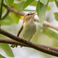
GREAT FOR IDENTIFICATION
“Seek is great for identification. I moved the icon next to my Mad River Watch app on my home screen so that I could quickly switch between the apps,” said volunteer Julie Westervelt, Warren.
Another app the volunteers are exploring continues with the wildlife identification theme. Merlin also offers a place for people to record and share their findings. It can also record audio to help identify bird-song in real-time.
"These apps are free to download and are accessible to the public whether or not you volunteer with Mad River Watch," said Shadis. "You can use them just about any time you come face-to-face with the natural world. And, the data you collect while using them can be made available to scientists and help with important research."
“While iNaturalist and Merlin have a very sleek look, the HydroColor app is a little clunky and harder to approach,” he said, “but that doesn’t stop our intrepid volunteers from trying it out. The app is really cool, too. It uses data taken from the phone's camera and a pair of onsite photos to analyze a third water photo and give a reading for the amount of sediment suspended in the water. The amount of these suspended sediments, also referred to as the turbidity level, is a measure of water quality itself and can point to erosion or runoff upstream.”
This week, both field days started with cooler temperatures that rose to the high 70s and low 80s. In spite of the heavy rain on July 5, water levels remain low across The Valley. Half of the sites visited were recorded as having a low flow, the other half had moderate flow, and none had high flow. These low water levels likely also contributed to the fairly warm water temperatures recorded as well. Water temperatures ranged from a low of 53.1 F at Clay Brook on Sunday to a high of 65.6 F at the Meadow Road site on Monday.