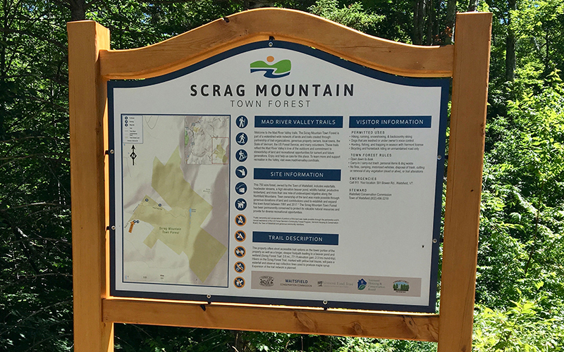
The Mad River Valley Planning District (MRVPD) reports that the installation of the Lower Woods Trail Network kiosk in November 2021 officially completes the MRV Unified Trailhead Kiosk and Mapping Project. The project, which launched in July 2018 with the first kiosk installation at Scrag Mountain Town Forest, features 47 total trailhead signs -- 15 major and 32 minor signs installed at publicly-accessible recreation fields, parks, village path segments, conserved forest land, multi-use paths, and more -- each with a site map, trail information and user guidelines that together identify, unify and celebrate the Mad River Valley’s trail network.
In addition to the kiosks, the project also included a substantial mapping component. The effort resulted in the creation, production and distribution of 2,000 paper trail network maps that were dispersed for free throughout The Valley at community libraries, town offices, elderly housing, public events and other gathering sites. The 2019 edition of the Mad River Valley Trail Map was produced in partnership with Maine-based cartographers Map Adventures and is currently available from local retailers and online. The map utilizes the latest trail data and descriptions to detail activities for hikers, bikers, skiers, snowshoers, swimmers and more, showcasing the vast, multi-use trail resources for recreationists in The Valley in one cohesive place. In addition to the paper trail maps, the trail data and narratives have been incorporated into the online Trail Finder platform, a free, interactive mapping site showcasing recreation options across Vermont and New Hampshire (https://www.trailfinder.info).
“Altogether, the kiosk and mapping project marks an important milestone in creating a unified Valley identity around shared core values of outdoor activity, community health and wellbeing, and environmental stewardship, as well as being active at any age and any stage. Prior to the kiosk project, communication of The Valley’s existing network of trails and active transportation corridors were managed through numerous entities; many access points lacked signage and those that did have signage told disparate messages. Through the completion of the kiosk project, the current conglomeration of trails has transformed into a unified network with consistent wayfinding signage and mapping,” explained Joshua Schwartz, Mad River Valley Planning District executive director.
“The new trailhead kiosks’ enhanced infrastructure and visibility removes barriers to recreation by promoting the wealth of open-access opportunities for all, including youth, elderly, those with limited mobility or who may feel uncomfortable in traditional gym settings, people who want to be active with their children and/or pets, those seeking recreational pursuits free of barriers such as user fees, students who may prefer individual active journeys to formal sports teams and recreation enthusiasts alike,” Schwartz added.
The Mad River Valley Trailhead Kiosk & Mapping Project is an initiative of the Mad River Valley Trails Collaborative, representing more than a dozen stakeholder organizations who convene to coordinate and improve trail-based recreation in the Valley. This work culminated in the 2016 MRV Moves Active Transportation Plan, which lays out the framework for a consistent, cohesive and connected regional system of trails, roads and sidewalks that provide a range of transportation options and recreational experiences for all. In September 2017, the trails collaborative identified trail signage as a key priority in enhancing the economic and community benefits associated with recreation. In terms of economic benefits, the 2015 Mad River Valley Moves Community Survey found that visitors engaged in recreation in The Valley spent an average of $174.87 per person, per day.
“A well-developed trail network with improved accessibility is a crucial part of attracting and maintaining tourism year-round, as well as promoting a sustainable and diverse local economy,” Schwartz said.
The Trails Collaborative launched the trail identification effort with project management and direction provided by the MRVPD, $25,500 in municipal funding (Waitsfield, Warren and Fayston), $33,000 in grants from Vermont Department of Buildings & General Services and the Vermont Department of Health, and extensive participation from local partners including the Mad River Path Association, Mad River Riders, Mad River Valley Chamber, Mad River Ridge Runners, Friends of the Mad River, Sugarbush Resort, Waitsfield, Warren and Fayston Conservation Commissions, Moretown Recreation Committee, Central Vermont Regional Planning Commission, Vermont Land Trust, Vermont Department of Forest, Parks and Recreation, the US Forest Service, and others.
“Many hands and minds have touched this project,” Schwartz added. “The culmination of this effort is a truly special signage system that celebrates the unique character of many different recreational sites, while also reflecting our unity as a Mad River Valley community. We hope the beauty and rustic character of these signs convey a clear message: enjoy the Valley, and help us care for this place.”
The kiosks consist of a signage designed and produced by Wood & Wood Sign Systems, map development provided by Brian Voigt, and local hemlock sign structures fabricated through the generosity of Fayston resident Seth Henry with support of many volunteers. Cartography services for the MRV Trail Maps were provided by Map Adventures, and Trail Finder digital mapping undertaken by the Upper Valley Trail Alliance and the Center for Community GIS.
“The planning district extends its gratitude to these contributors as well the 78 community trail stakeholders who contributed time, ideas, and resources to realize this transformative community initiative,” Schwartz said.