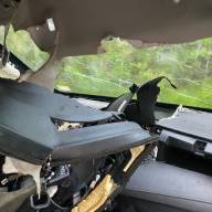
Heavy rains last week on Thursday and Friday damaged roads in Warren and Waitsfield, resulting in closures and repair work.

Airport Road in Warren experienced several deep washouts and the town’s Dump Road was closed for several days due to a washout just below Otter Lane where the road was undermined. That road is expected to be reopened by press time on September 13.
Rolston Road in Waitsfield also experienced deep washouts on its steepest, narrowest sections, according to town administrator Annie Decker-Dell’Isola who said that town road crews would be repairing that road in the next few days and that it would likely be closed during the day when that work was underway. Town resident Russ Chalom came to the town select board’s September 11 meeting to detail damage to Dana Hill Road.
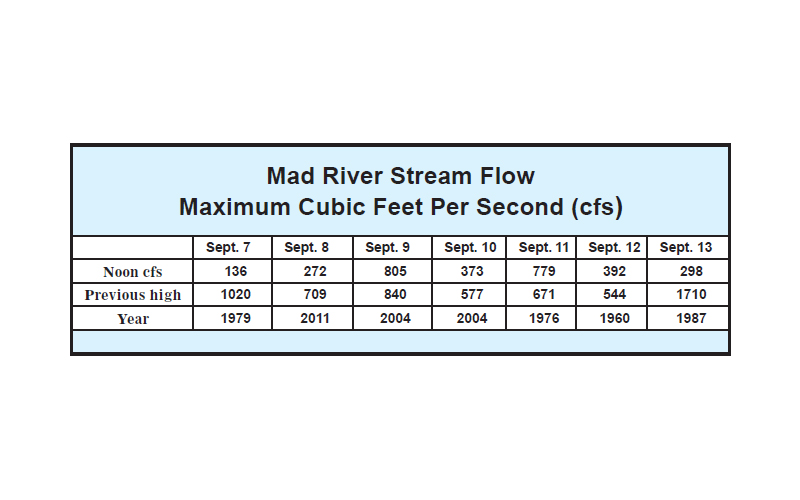
See this week’s Mad River stream flow chart which captures stream flow at noon every day. This week’s chart does not show precipitation which the USGS gage does show. Between September 8 and 10, 1.5 inches of rain fell at the Moretown gage and then another 1.25 inches fell by September 11.
That led to a peak flow of 4,000 cubic feet per second early in the morning of September 9 which well throughout the next days, rising again to almost 1,000 on September 11. The chart does not reflect those peak flows due to when The Valley Reporter is recording daily flows, but there were still several maximum stream flow records broken this week. Readers can monitor the stream gage in real time by searching for USGS stream gage near Moretown, Vermont, or USGS stream gage 04288000.